
This quiz should be an easy one for
YG. At different times, he came across to me as an
entomologist (insect expert), an
ornithologist (bird expert) or a
botanist (plant expert). I believe YG's former profession as a
teacher has something to do with his wide knowledge of diversified topics, except perhaps only in
investment. :p Obviously, YG made a very good teacher.
So far, YG has never shown himself to be a petrologist. That is a rock expert, not of the music kind, according to
this Wikipedia link. (Hmm... I wonder what do they call someone who studies petrol?) However, as YG seems to have been all over our little island of late, he must have seen this rock before. So YG, what's your answer?
As for me, I am no rock expert myself. I only know how to talk rocks. :p
Answer To Quiz - Updated on 26 Dec 2008YG, Chun See and Icemoon obviously knew the answer to the quiz right away but they didn't want to spoil the game for the rest. Yes, the answer is Bukit Timah Summit.
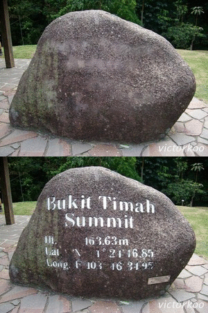
The inscription says:
Bukit Timah Summit
Ht. 163.63m
Lat. N 1 deg 21' 16.85"
Long. E 103 deg 46' 34.95"
The climb to the summit is about half an hour to one hour, depending on how fast you climb. If you do it slowly, the walk can be quite romantic.

A tree trunk with a heart-shaped cross section. Ain't it lovely?

Take your time to see nature at its best. You can admire the long-tailed macaques but
don't feed them. Your act may hurt your pocket more than their hunger may hurt them. ;) But more importantly, feeding the macaques will alter their feeding habits and make them associate human beings with food. They become reliant on us for food and may even turn aggressive if they don't get what they want. In fact, I witnessed a macaque snatching a plastic bag containing a water bottle from an unwary woman. It was quite scary.

The last part of the climb is a flight of stairs. This is a shortcut. If you take the road, the climb is less steep but it is further, naturally (pun intended).
After an arduous climb (for people of my age), I finally reached the summit.

If you are lucky, you might even see some unusual sights. On the day I was there, Mediacorp was filming on location.

The man in pink shirt was
Director Michael Woo.

Come on. If
Michael Woo I can make it to the summit, surely you can too. Make an attempt, if you haven't. I'm sure you will not regret it.
The Bukit Timah Summit
At the Bukit Timah Summit, there is a sign that reads:
"You have reached the top of Singapore's highest natural point at 163.8 metres. The first men to reach the summit was Singapore's Resident Councillor John Prince and his contractors in June 1827.
It took them five hours to cover a distance of 22.5 kilometres of plantations, hills and swamps from the south. A white flag was hoisted up the tallest tree, which could be seen from as far as Fort Canning Hill. The access road to the summit was built in 1843.
Believe it or not! Once upon a time .... where the tigers roamed. 'Bukit Timah was known to be horrid tiger-infested, forested blob to the early Colonials where tiger roars can be heard at twilight.' - A View From The Summit"
Battle For Bukit TimahThe inscription on the plaque near the Visitor Centre reads as follows:
"Bukit Timah, which dominates the arterial Bukit Timah and Dunearn Roads leading to the city, was a strategically important point for both the Allied troops and the Japanese.
On the night of 10th February 1942, the Japanese troops from the 5th and 18th Divisions, supported by armour, attacked troops of the 12th and 15th Indian Brigades, the 22nd Australian Brigade, The Special Reserve Battalion, Tomforce, Merrett's Force, the Argylls, Jind State Infantry and 'X' Battalion. The Allied forces had re-grouped to defend the critical junctions at Choa Chu Kang, Jurong and Clementi Roads leading to Bukit Timah Road.
By dawn of 11th February 1942, the Japanese troops reported to their commander Lieutenant General Tomoyuki Yamashita that they had seized Bukit Timah. The road to the city was open."







 Posts
Posts


